Division of Adelaide
Division of Adelaide is a federal electorate in South Australia, covering about 86.4 km². Its federal member is Steve Georganas (Australian Labor Party). State electorates overlapping it include Adelaide, Croydon, Enfield, West Torrens. Local council areas overlapping it include City of Port Adelaide Enfield, City of Adelaide, City of West Torrens, City of Unley.
- Level
- Federal electorate
- State / territory
- South Australia (SA)
- Area
- about 86.4 km²
- Federal member
- Steve Georganas — Australian Labor Party
- Official source
- AEC electorate profile
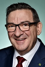
On Political Gadgets
State electorates overlapping Adelaide
| Adelaide (SA state electorate) | 26% of this federal electorate | >99% of Adelaide |
| Croydon (SA state electorate) | 24% of this federal electorate | >99% of Croydon |
| Enfield (SA state electorate) | 15% of this federal electorate | 66% of Enfield |
| West Torrens (SA state electorate) | 14% of this federal electorate | 71% of West Torrens |
| Unley (SA state electorate) | 10% of this federal electorate | 55% of Unley |
| Badcoe (SA state electorate) | 6% of this federal electorate | 37% of Badcoe |
| Torrens (SA state electorate) | 4% of this federal electorate | 18% of Torrens |
Local council areas overlapping Adelaide
| City of Port Adelaide Enfield | 30% of this federal electorate | 28% of City of Port Adelaide Enfield |
| City of Adelaide | 18% of this federal electorate | >99% of City of Adelaide |
| City of West Torrens | 16% of this federal electorate | 37% of City of West Torrens |
| City of Unley | 12% of this federal electorate | 70% of City of Unley |
| City of Charles Sturt | 11% of this federal electorate | 17% of City of Charles Sturt |
| City of Prospect | 9% of this federal electorate | >99% of City of Prospect |
| The Corporation of the Town of Walkerville | 4% of this federal electorate | >99% of The Corporation of the Town of Walkerville |
Suburbs in Adelaide
Suburbs with at least a quarter of their area inside this federal electorate. Select one to see all three levels of electorate.
- Adelaide 5000
- Allenby Gardens 5009
- Angle Park 5010
- Ashford 5035
- Blair Athol 5084
- Bowden 5007
- Broadview 5083
- Brompton 5007
- Clearview 5085
- Collinswood 5081
- Cowandilla 5033
- Croydon 5008
- Croydon Park 5008
- Devon Park 5008
- Dudley Park 5008
- Eastwood 5063
- Enfield 5085
- Everard Park 5035
- Ferryden Park 5010
- Fitzroy 5082
- Forestville 5035
- Fullarton 5063
- Gilberton 5081
- Glandore 5037
- Goodwood 5034
- Greenacres 5086
- Hampstead Gardens 5086
- Highgate 5063
- Hilton 5033
- Hindmarsh 5007
- Hyde Park 5061
- Keswick 5035
- Keswick Terminal 5035
- Kilburn 5084
- Kilkenny 5009
- Kurralta Park 5037
- Lightsview 5085
- Malvern 5061
- Manningham 5086
- Mansfield Park 5012
- Marleston 5033
- Medindie 5081
- Medindie Gardens 5081
- Mile End 5031
- Mile End South 5031
- Millswood 5034
- Nailsworth 5083
- North Adelaide 5006
- North Plympton 5037
- Northfield 5085
- Northgate 5085
- Ovingham 5082
- Parkside 5063
- Plympton 5038
- Prospect 5082
- Regency Park 5010
- Renown Park 5008
- Richmond 5033
- Ridleyton 5008
- Sefton Park 5083
- Thebarton 5031
- Thorngate 5082
- Torrensville 5031
- Underdale 5032
- Unley 5061
- Unley Park 5061
- Vale Park 5081
- Walkerville 5081
- Wayville 5034
- Welland 5007
- West Croydon 5008
- West Hindmarsh 5007
- Woodville Gardens 5012
Questions
Who is the federal member for Adelaide?
Steve Georganas of the Australian Labor Party is the federal member for the Division of Adelaide in the House of Representatives.
Which council areas are in the Division of Adelaide?
Council areas overlapping it include City of Port Adelaide Enfield, City of Adelaide, City of West Torrens, City of Unley, City of Charles Sturt, City of Prospect.
Which state electorates are in the Division of Adelaide?
State electorates overlapping it include Adelaide, Croydon, Enfield, West Torrens, Unley, Badcoe.
Which suburbs are in Adelaide?
Suburbs mostly inside it include Allenby Gardens, Ashford, Bowden, Broadview, Brompton, Collinswood, Cowandilla, Croydon.
How accurate is this?
Boundaries are simplified (about 40 m tolerance), so overlap percentages are approximate. For anything official, such as enrolment or voting, check the Australian Electoral Commission or your state electoral commission.
← All federal electorates · Find My Electorates
Federal boundaries: Australian Electoral Commission (as at the 2025 federal election). State and council boundaries: incorporates or developed using Administrative Boundaries © Geoscape Australia licensed under CC BY 4.0.