Division of Corio
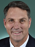
Division of Corio is a federal electorate in Victoria, covering about 1,216 km². Its federal member is Richard Marles (Australian Labor Party). State electorates overlapping it include Lara, Geelong, Werribee, Eureka. Local council areas overlapping it include Greater Geelong City, Golden Plains Shire, Wyndham City.
- Level
- Federal electorate
- State / territory
- Victoria (VIC)
- Area
- about 1,216 km²
- Federal member
- Richard Marles — Australian Labor Party
- Role
- Deputy Prime Minister Minister for Defence
- Official source
- AEC electorate profile
On Political Gadgets
State electorates overlapping Corio
| Lara (VIC state electorate) | 57% of this federal electorate | >99% of Lara |
| Geelong (VIC state electorate) | 24% of this federal electorate | 90% of Geelong |
| Werribee (VIC state electorate) | 14% of this federal electorate | 52% of Werribee |
| Eureka (VIC state electorate) | 3% of this federal electorate | <1% of Eureka |
Local council areas overlapping Corio
| Greater Geelong City | 63% of this federal electorate | 60% of Greater Geelong City |
| Golden Plains Shire | 22% of this federal electorate | 10% of Golden Plains Shire |
| Wyndham City | 14% of this federal electorate | 32% of Wyndham City |
Suburbs in Corio
Suburbs with at least a quarter of their area inside this federal electorate. Select one to see all three levels of electorate.
- Anakie 3213
- Avalon 3212
- Balliang 3340
- Bannockburn 3331
- Batesford 3213
- Bell Park 3215
- Bell Post Hill 3215
- Belmont 3216
- Breakwater 3219
- Cocoroc 3030
- Corio 3214
- Drumcondra 3215
- East Geelong 3219
- Fyansford 3218
- Geelong 3220
- Geelong West 3218
- Gheringhap 3331
- Hamlyn Heights 3215
- Herne Hill 3218
- Highton 3216
- Lara 3212
- Little River 3211
- Lovely Banks 3213
- Mambourin 3024
- Manifold Heights 3218
- Maude 3331
- Moorabool 3213
- Murgheboluc 3218
- Newcomb 3219
- Newtown (Greater Geelong - Vic.) 3220
- Norlane 3214
- North Geelong 3215
- North Shore 3214
- Point Wilson 3212
- Rippleside 3215
- Russells Bridge 3331
- South Geelong 3220
- St Albans Park 3219
- Staughton Vale 3340
- Stonehaven 3218
- Sutherlands Creek 3331
- Thomson (Greater Geelong - Vic.) 3219
- Wandana Heights 3216
- Whittington 3219
Questions
Who is the federal member for Corio?
Richard Marles of the Australian Labor Party is the federal member for the Division of Corio in the House of Representatives.
Which council areas are in the Division of Corio?
Council areas overlapping it include Greater Geelong City, Golden Plains Shire, Wyndham City.
Which state electorates are in the Division of Corio?
State electorates overlapping it include Lara, Geelong, Werribee, Eureka.
Which suburbs are in Corio?
Suburbs mostly inside it include Batesford, Bell Park, Bell Post Hill, Geelong West, Gheringhap, Hamlyn Heights, Herne Hill, Lara.
How accurate is this?
Boundaries are simplified (about 40 m tolerance), so overlap percentages are approximate. For anything official, such as enrolment or voting, check the Australian Electoral Commission or your state electoral commission.
← All federal electorates · Find My Electorates
Federal boundaries: Australian Electoral Commission (as at the 2025 federal election). State and council boundaries: incorporates or developed using Administrative Boundaries © Geoscape Australia licensed under CC BY 4.0.