Division of Shortland
Division of Shortland is a federal electorate in New South Wales, covering about 270 km². Its federal member is Pat Conroy (Australian Labor Party). State electorates overlapping it include Swansea, Charlestown, Lake Macquarie, Wallsend. Local council areas overlapping it include Lake Macquarie City Council, Central Coast Council.
- Level
- Federal electorate
- State / territory
- New South Wales (NSW)
- Area
- about 270 km²
- Federal member
- Pat Conroy — Australian Labor Party
- Role
- Minister for Pacific Island Affairs Minister for Defence Industry
- Official source
- AEC electorate profile
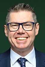
On Political Gadgets
State electorates overlapping Shortland
| Swansea (NSW state electorate) | 71% of this federal electorate | 97% of Swansea |
| Charlestown (NSW state electorate) | 20% of this federal electorate | 81% of Charlestown |
| Lake Macquarie (NSW state electorate) | 6% of this federal electorate | 3% of Lake Macquarie |
| Wallsend (NSW state electorate) | 2% of this federal electorate | 5% of Wallsend |
Local council areas overlapping Shortland
| Lake Macquarie City Council | 70% of this federal electorate | 25% of Lake Macquarie City Council |
| Central Coast Council | 30% of this federal electorate | 4% of Central Coast Council |
Suburbs in Shortland
Suburbs with at least a quarter of their area inside this federal electorate. Select one to see all three levels of electorate.
- Argenton 2284
- Belmont 2280
- Belmont North 2280
- Belmont South 2280
- Bennetts Green 2290
- Blacksmiths 2281
- Boolaroo 2284
- Budgewoi 2262
- Budgewoi Peninsula 2262
- Buff Point 2262
- Cams Wharf 2281
- Cardiff 2285
- Cardiff Heights 2285
- Cardiff South 2285
- Catherine Hill Bay 2281
- Caves Beach 2281
- Chain Valley Bay 2259
- Charlestown 2290
- Colongra 2262
- Crangan Bay 2259
- Croudace Bay 2280
- Doyalson 2262
- Doyalson North 2262
- Dudley 2290
- Eleebana 2282
- Floraville 2280
- Frazer Park 2259
- Freemans 2259
- Garden Suburb 2289
- Gateshead 2290
- Glendale 2285
- Gwandalan 2259
- Halekulani 2262
- Highfields 2289
- Hillsborough (Lake Macquarie) 2290
- Jewells 2280
- Kahibah 2290
- Kingfisher Shores 2259
- Kotara South 2289
- Lake Macquarie 2259
- Lake Munmorah 2259
- Lakelands 2282
- Little Pelican 2281
- Macquarie Hills 2285
- Mannering Park 2259
- Marks Point 2280
- Moonee 2259
- Mount Hutton 2290
- Murrays Beach 2281
- Nords Wharf 2281
- Pelican 2281/2280
- Pinny Beach 2281
- Point Wolstoncroft 2259
- Redhead 2290
- San Remo 2262
- Speers Point 2284
- Summerland Point 2259
- Swansea 2281
- Swansea Heads 2281
- Tingira Heights 2290
- Valentine 2280
- Warners Bay 2282
- Whitebridge 2290
- Windale 2306
- Wybung 2259
Questions
Who is the federal member for Shortland?
Pat Conroy of the Australian Labor Party is the federal member for the Division of Shortland in the House of Representatives.
Which council areas are in the Division of Shortland?
Council areas overlapping it include Lake Macquarie City Council, Central Coast Council.
Which state electorates are in the Division of Shortland?
State electorates overlapping it include Swansea, Charlestown, Lake Macquarie, Wallsend.
Which suburbs are in Shortland?
Suburbs mostly inside it include Belmont, Belmont North, Bennetts Green, Buff Point, Cams Wharf, Cardiff South, Chain Valley Bay, Charlestown.
How accurate is this?
Boundaries are simplified (about 40 m tolerance), so overlap percentages are approximate. For anything official, such as enrolment or voting, check the Australian Electoral Commission or your state electoral commission.
← All federal electorates · Find My Electorates
Federal boundaries: Australian Electoral Commission (as at the 2025 federal election). State and council boundaries: incorporates or developed using Administrative Boundaries © Geoscape Australia licensed under CC BY 4.0.