Division of Robertson
Division of Robertson is a federal electorate in New South Wales, covering about 1,024 km². Its federal member is Gordon Reid (Australian Labor Party). State electorates overlapping it include Gosford, Terrigal. Local council areas overlapping it include Central Coast Council.
- Level
- Federal electorate
- State / territory
- New South Wales (NSW)
- Area
- about 1,024 km²
- Federal member
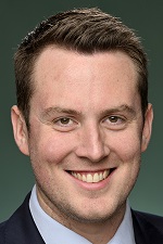
- Gordon Reid — Australian Labor Party
- Official source
- AEC electorate profile
On Political Gadgets
State electorates overlapping Robertson
| Gosford (NSW state electorate) | 89% of this federal electorate | >99% of Gosford |
| Terrigal (NSW state electorate) | 10% of this federal electorate | 77% of Terrigal |
Local council areas overlapping Robertson
| Central Coast Council | >99% of this federal electorate | 55% of Central Coast Council |
Suburbs in Robertson
Suburbs with at least a quarter of their area inside this federal electorate. Select one to see all three levels of electorate.
- Avoca Beach 2251
- Bar Point 2083
- Bensville 2251
- Blackwall 2256
- Booker Bay 2257
- Bouddi 2257
- Box Head 2257
- Calga 2250
- Central Mangrove 2250
- Cheero Point 2083
- Cogra Bay 2083
- Copacabana 2251
- Daleys Point 2257
- Davistown 2251
- East Gosford 2250
- Empire Bay 2257
- Erina 2250
- Erina Heights 2260
- Ettalong Beach 2257
- Glenworth Valley 2250
- Gosford 2250
- Green Point (Central Coast) 2251
- Greengrove 2250
- Gunderman 2775
- Hardys Bay 2257
- Horsfield Bay 2256
- Kariong 2250
- Killcare 2257
- Killcare Heights 2257
- Kincumber 2251
- Kincumber South 2251
- Koolewong 2256
- Kulnura 2250
- Little Wobby 2256
- Lower Mangrove 2250
- Macmasters Beach 2251
- Mangrove Creek 2250
- Mangrove Mountain 2250
- Marlow 2775
- Mooney Mooney 2083
- Mooney Mooney Creek 2250
- Mount White 2250
- Narara 2250
- Niagara Park 2250
- North Avoca 2260
- North Gosford 2250
- Patonga 2256
- Pearl Beach 2256
- Peats Ridge 2250
- Phegans Bay 2256
- Picketts Valley 2251
- Point Clare 2250
- Point Frederick 2250
- Pretty Beach (Central Coast) 2257
- Saratoga 2251
- Somersby 2250
- Spencer 2775
- Springfield (Central Coast) 2250
- St Huberts Island 2257
- Tascott 2250
- Ten Mile Hollow 2250
- Terrigal 2260
- Umina Beach 2257
- Upper Mangrove 2250
- Wagstaffe 2257
- Wendoree Park 2250
- West Gosford 2250
- Wondabyne 2256
- Woy Woy 2256
- Woy Woy Bay 2256
- Yattalunga 2251
Questions
Who is the federal member for Robertson?
Gordon Reid of the Australian Labor Party is the federal member for the Division of Robertson in the House of Representatives.
Which council areas are in the Division of Robertson?
Council areas overlapping it include Central Coast Council.
Which state electorates are in the Division of Robertson?
State electorates overlapping it include Gosford, Terrigal.
Which suburbs are in Robertson?
Suburbs mostly inside it include Bar Point, Bensville, Blackwall, Booker Bay, Calga, Cheero Point, Cogra Bay, Daleys Point.
How accurate is this?
Boundaries are simplified (about 40 m tolerance), so overlap percentages are approximate. For anything official, such as enrolment or voting, check the Australian Electoral Commission or your state electoral commission.
← All federal electorates · Find My Electorates
Federal boundaries: Australian Electoral Commission (as at the 2025 federal election). State and council boundaries: incorporates or developed using Administrative Boundaries © Geoscape Australia licensed under CC BY 4.0.