Division of Riverina
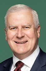
Division of Riverina is a federal electorate in New South Wales, covering about 52,410 km². Its federal member is Michael McCormack (National Party). State electorates overlapping it include Cootamundra, Wagga Wagga, Goulburn, Albury. Local council areas overlapping it include Snowy Valleys Council, Hilltops Council, Upper Lachlan Shire Council, Wagga Wagga City Council.
- Level
- Federal electorate
- State / territory
- New South Wales (NSW)
- Area
- about 52,410 km²
- Federal member
- Michael McCormack — National Party
- Official source
- AEC electorate profile
On Political Gadgets
State electorates overlapping Riverina
| Cootamundra (NSW state electorate) | 47% of this federal electorate | 66% of Cootamundra |
| Wagga Wagga (NSW state electorate) | 23% of this federal electorate | >99% of Wagga Wagga |
| Goulburn (NSW state electorate) | 21% of this federal electorate | 68% of Goulburn |
| Albury (NSW state electorate) | 9% of this federal electorate | 28% of Albury |
Local council areas overlapping Riverina
| Snowy Valleys Council | 17% of this federal electorate | >99% of Snowy Valleys Council |
| Hilltops Council | 14% of this federal electorate | >99% of Hilltops Council |
| Upper Lachlan Shire Council | 14% of this federal electorate | >99% of Upper Lachlan Shire Council |
| Wagga Wagga City Council | 9% of this federal electorate | >99% of Wagga Wagga City Council |
| Yass Valley Council | 8% of this federal electorate | >99% of Yass Valley Council |
| Cootamundra-Gundagai Regional Council | 8% of this federal electorate | >99% of Cootamundra-Gundagai Regional Council |
| Weddin Shire Council | 7% of this federal electorate | >99% of Weddin Shire Council |
| Lockhart Shire Council | 6% of this federal electorate | >99% of Lockhart Shire Council |
| Cowra Shire Council | 5% of this federal electorate | >99% of Cowra Shire Council |
| Temora Shire Council | 5% of this federal electorate | >99% of Temora Shire Council |
| Coolamon Shire Council | 5% of this federal electorate | >99% of Coolamon Shire Council |
| Junee Shire Council | 4% of this federal electorate | >99% of Junee Shire Council |
Suburbs in Riverina
Suburbs with at least a quarter of their area inside this federal electorate. Select one to see all three levels of electorate.
- Adelong 2729
- Adjungbilly 2727
- Alfredtown 2650
- Argalong 2720
- Ashmont 2650
- Bangadang 2729
- Bango 2582
- Barwang 2594
- Batlow 2730
- Bectric 2665
- Beggan Beggan 2587
- Belfrayden 2650
- Bellmount Forest 2581
- Bendick Murrell 2803
- Berremangra 2582
- Berry Jerry 2701
- Berthong 2594
- Bethungra 2590
- Bevendale 2581
- Biala 2581
- Bidgeemia 2642
- Big Springs 2650
- Billimari 2804
- Bimbi 2810
- Binalong 2584
- Binda 2583
- Black Creek (Snowy Valleys) 2729
- Blakney Creek 2581
- Blowering 2720
- Boambolo 2582
- Bogong Peaks Wilderness 2720
- Bombowlee 2720
- Bombowlee Creek 2720
- Bomen 2650
- Book Book 2650
- Bookham 2582
- Boorooma 2650
- Boorowa 2586
- Borambola 2650
- Bourkelands 2650
- Bowning 2582
- Broadway 2581
- Brookdale 2656
- Brookong 2656
- Brucedale 2650
- Brungle 2722
- Brungle Creek 2722
- Buddong 2720
- Bulgary 2650
- Bulla Creek 2594
- Bumbaldry 2794
- Burra (Snowy Valleys) 2653
- Burra Creek 2722
- Burrandana 2650
- Burrangong 2594
- Burrinjuck 2582
- Califat 2729
- Cartwrights Hill 2650
- Cavan 2582
- Charles Sturt University 2678
- Collingullie 2650
- Combaning 2666
- Coolac 2727
- Coolamon 2701
- Cooleys Creek 2729
- Cootamundra 2590
- Courabyra 2653
- Couragago 2720
- Cowra 2794
- Crooked Corner 2583
- Crookwell 2583
- Crowther 2803
- Cullerin 2581
- Cullivel 2645
- Cunningar 2587
- Currawarna 2650
- Dalton 2581
- Darbalara 2722
- Darbys Falls 2793
- Darlow 2729
- Dhulura 2650
- Dirnaseer 2666
- Downside 2650
- East Wagga Wagga 2650
- Ellerslie (Snowy Valleys) 2729
- Erin Vale 2663
- Estella 2650
- Euberta 2650
- Eunanoreenya 2650
- Eurongilly 2663
- Forest Hill 2651
- French Park 2655
- Frogmore 2586
- Gadara 2720
- Galong 2585
- Ganmain 2702
- Gelston Park 2650
- Gidginbung 2666
- Gilmore 2720
- Glenfield Park 2650
- Gobarralong 2722
- Gobbagombalin 2650
- Gocup 2720
- Godfreys Creek 2586
- Goobarragandra 2720
- Good Hope 2582
- Grabben Gullen 2583
- Grahamstown 2729
- Green Hills (Snowy Valleys) 2730
- Greenethorpe 2809
- Gregadoo 2650
- Grenfell 2810
- Grogan 2666
- Gumly Gumly 2652
- Gundagai 2722
- Gunning 2581
- Harden 2587
- Harefield 2650
- Hillgrove (Wagga Wagga) 2650
- Hovells Creek 2794
- Illabo 2590
- Jagumba 2642
- Jeir 2582
- Jerrawa 2582
- Jones Bridge 2720
- Jugiong 2726
- Junee 2663
- Junee Reefs 2666
- Kangiara 2582
- Kapooka 2661
- Khancoban 2642
- Kikiamah 2594
- Killimicat 2720
- Kingsvale 2587
- Koorawatha 2807
- Kooringal 2650
- Kunama 2730
- Lacmalac 2720
- Lade Vale 2581
- Ladysmith 2652
- Laggan 2583
- Lake Albert 2650
- Laurel Hill 2649
- Laverstock 2582
- Lerida 2581
- Limerick 2583
- Little River 2720
- Lloyd 2650
- Lockhart 2656
- Lost River 2583
- Lower Bago 2730
- Maimuru 2594
- Mannus 2653
- Manton 2582
- Maragle 2653
- Marchmont 2582
- Marinna 2663
- Marrar 2652
- Maxwell 2650
- McMahons Reef 2587
- Memagong 2594
- Merrill 2581
- Methul 2701
- Milbrulong 2656
- Milvale 2594
- Mimosa 2666
- Minjary 2720
- Monteagle 2594
- Moorong 2650
- Mount Adrah 2722
- Mount Austin 2650
- Mount Collins 2794
- Mount Horeb 2729
- Mullion 2582
- Mundarlo 2729
- Mundongo 2720
- Munyabla 2658
- Murringo 2586
- Murrulebale 2652
- Murrumbateman 2582
- Murrumburrah 2587
- Muttama 2722
- Myrtleville 2580
- Nangus 2722
- Nanima 2582
- Narraburra 2666
- Narrangullen 2582
- Narrawa 2583
- North Wagga Wagga 2650
- Nubba 2587
- Nurenmerenmong 2649
- Old Junee 2652
- Oolong 2581
- Osborne 2656
- Oura 2650
- Paddys River (Snowy Valleys) 2653
- Pejar 2583
- Pinbeyan 2720
- Piney Range 2810
- Pleasant Hills 2658
- Pucawan 2666
- Quandary 2665
- Rannock 2701
- Red Hill (Snowy Valleys) 2720
- Reids Flat 2586
- Reno 2722
- Richlands 2580
- Roslyn 2580
- Rowan 2650
- Rugby 2583
- Ryan 2658
- Rye Park 2586
- San Isidore 2650
- Sandy Gully 2729
- Sebastopol 2666
- Sharps Creek 2729
- South Gundagai 2722
- Springdale 2666
- Springvale 2650
- Stockinbingal 2725
- Stonequarry 2580
- Talbingo 2720
- Tara 2665
- Taradale 2653
- Taralga 2580
- Tarcutta 2652
- Tatton 2650
- Taylors Flat 2586
- Temora 2666
- The Gap (Wagga Wagga) 2650
- The Rock 2655
- Thuddungra 2594
- Tolland 2650
- Tooma 2642
- Tootool 2655
- Trungley Hall 2666
- Tubbul 2594
- Tumbarumba 2653
- Tumblong 2729
- Tumorrama 2720
- Tumut 2720
- Tumut Plains 2720
- Turvey Park 2650
- Urangeline 2656
- Uranquinty 2652
- Uriarra 2611
- Wagga Wagga 2650
- Wallacetown 2650
- Wallaroo 2618
- Wallendbeen 2588
Showing 250 of 354 suburbs.
Questions
Who is the federal member for Riverina?
Michael McCormack of the National Party is the federal member for the Division of Riverina in the House of Representatives.
Which council areas are in the Division of Riverina?
Council areas overlapping it include Snowy Valleys Council, Hilltops Council, Upper Lachlan Shire Council, Wagga Wagga City Council, Yass Valley Council, Cootamundra-Gundagai Regional Council.
Which state electorates are in the Division of Riverina?
State electorates overlapping it include Cootamundra, Wagga Wagga, Goulburn, Albury.
Which suburbs are in Riverina?
Suburbs mostly inside it include Adelong, Adjungbilly, Alfredtown, Argalong, Ashmont, Bangadang, Bango, Barwang.
How accurate is this?
Boundaries are simplified (about 40 m tolerance), so overlap percentages are approximate. For anything official, such as enrolment or voting, check the Australian Electoral Commission or your state electoral commission.
← All federal electorates · Find My Electorates
Federal boundaries: Australian Electoral Commission (as at the 2025 federal election). State and council boundaries: incorporates or developed using Administrative Boundaries © Geoscape Australia licensed under CC BY 4.0.