Division of Paterson
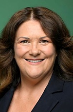
Division of Paterson is a federal electorate in New South Wales, covering about 1,034 km². Its federal member is Meryl Swanson (Australian Labor Party). State electorates overlapping it include Port Stephens, Maitland, Cessnock, Newcastle. Local council areas overlapping it include Port Stephens Council, Maitland City Council, Cessnock City Council, Newcastle City Council.
- Level
- Federal electorate
- State / territory
- New South Wales (NSW)
- Area
- about 1,034 km²
- Federal member
- Meryl Swanson — Australian Labor Party
- Official source
- AEC electorate profile
On Political Gadgets
State electorates overlapping Paterson
| Port Stephens (NSW state electorate) | 57% of this federal electorate | 46% of Port Stephens |
| Maitland (NSW state electorate) | 25% of this federal electorate | >99% of Maitland |
| Cessnock (NSW state electorate) | 11% of this federal electorate | 5% of Cessnock |
| Newcastle (NSW state electorate) | 4% of this federal electorate | 33% of Newcastle |
| Wallsend (NSW state electorate) | 3% of this federal electorate | 29% of Wallsend |
Local council areas overlapping Paterson
| Port Stephens Council | 60% of this federal electorate | 64% of Port Stephens Council |
| Maitland City Council | 25% of this federal electorate | 65% of Maitland City Council |
| Cessnock City Council | 11% of this federal electorate | 6% of Cessnock City Council |
| Newcastle City Council | 5% of this federal electorate | 22% of Newcastle City Council |
Suburbs in Paterson
Suburbs with at least a quarter of their area inside this federal electorate. Select one to see all three levels of electorate.
- Aberglasslyn 2320
- Allandale 2320
- Anambah 2320
- Anna Bay 2316
- Ashtonfield 2323
- Beresfield 2322
- Berry Park 2321
- Bishops Bridge 2326
- Black Hill 2322
- Boat Harbour (Port Stephens) 2316
- Bobs Farm 2316
- Buchanan 2323
- Buttai 2323
- Campvale 2318
- Chisholm 2322
- Cliftleigh 2321
- Corlette 2315
- Duckenfield 2321
- Eagleton 2324
- East Maitland 2323
- Farley 2320
- Fern Bay 2295
- Ferodale 2318
- Fingal Bay 2315
- Fishermans Bay 2316
- Fullerton Cove 2318
- Gillieston Heights 2321
- Gosforth 2320
- Harpers Hill 2321
- Heatherbrae 2324
- Heddon Greta 2321
- Horseshoe Bend 2320
- Lemon Tree Passage 2319
- Lenaghan 2322
- Lochinvar 2321
- Louth Park 2320
- Loxford 2326
- Maitland 2320
- Mallabula 2319
- Medowie 2318
- Metford 2323
- Millers Forest 2324
- Morpeth 2321
- Mount Dee 2320
- Nelson Bay 2315
- Oakhampton 2320
- Oakhampton Heights 2320
- One Mile 2316
- Oswald 2321
- Oyster Cove 2318
- Pitnacree 2323
- Port Stephens 2319/2324
- Raworth 2321
- Raymond Terrace 2324
- Rutherford 2320
- Salamander Bay 2317
- Salt Ash 2318
- Sawyers Gully 2326
- Seahampton 2286
- Shoal Bay 2315
- Soldiers Point 2317
- South Maitland 2320
- Stockrington 2322
- Swan Bay (Port Stephens) 2324
- Tanilba Bay 2319
- Tarro 2322
- Taylors Beach 2316
- Telarah 2320
- Tenambit 2323
- Thornton 2322
- Tilligerry Creek 2319
- Tomago 2322
- Williamtown 2318
- Windella 2320
- Windermere 2321
- Woodberry 2322
Questions
Who is the federal member for Paterson?
Meryl Swanson of the Australian Labor Party is the federal member for the Division of Paterson in the House of Representatives.
Which council areas are in the Division of Paterson?
Council areas overlapping it include Port Stephens Council, Maitland City Council, Cessnock City Council, Newcastle City Council.
Which state electorates are in the Division of Paterson?
State electorates overlapping it include Port Stephens, Maitland, Cessnock, Newcastle, Wallsend.
Which suburbs are in Paterson?
Suburbs mostly inside it include Ashtonfield, Beresfield, Black Hill, Buttai, Campvale, Chisholm, Cliftleigh, Corlette.
How accurate is this?
Boundaries are simplified (about 40 m tolerance), so overlap percentages are approximate. For anything official, such as enrolment or voting, check the Australian Electoral Commission or your state electoral commission.
← All federal electorates · Find My Electorates
Federal boundaries: Australian Electoral Commission (as at the 2025 federal election). State and council boundaries: incorporates or developed using Administrative Boundaries © Geoscape Australia licensed under CC BY 4.0.