Division of McEwen
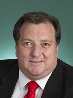
Division of McEwen is a federal electorate in Victoria, covering about 2,288 km². Its federal member is Rob Mitchell (Australian Labor Party). State electorates overlapping it include Macedon, Yan Yean, Eildon, Euroa. Local council areas overlapping it include Macedon Ranges Shire, Mitchell Shire, Whittlesea City, Nillumbik Shire.
- Level
- Federal electorate
- State / territory
- Victoria (VIC)
- Area
- about 2,288 km²
- Federal member
- Rob Mitchell — Australian Labor Party
- Official source
- AEC electorate profile
On Political Gadgets
State electorates overlapping McEwen
| Macedon (VIC state electorate) | 52% of this federal electorate | 35% of Macedon |
| Yan Yean (VIC state electorate) | 26% of this federal electorate | 98% of Yan Yean |
| Eildon (VIC state electorate) | 8% of this federal electorate | 2% of Eildon |
| Euroa (VIC state electorate) | 7% of this federal electorate | 1% of Euroa |
| Kalkallo (VIC state electorate) | 6% of this federal electorate | 52% of Kalkallo |
| Eltham (VIC state electorate) | 1% of this federal electorate | 37% of Eltham |
Local council areas overlapping McEwen
| Macedon Ranges Shire | 52% of this federal electorate | 67% of Macedon Ranges Shire |
| Mitchell Shire | 23% of this federal electorate | 18% of Mitchell Shire |
| Whittlesea City | 15% of this federal electorate | 69% of Whittlesea City |
| Nillumbik Shire | 10% of this federal electorate | 55% of Nillumbik Shire |
Suburbs in McEwen
Suburbs with at least a quarter of their area inside this federal electorate. Select one to see all three levels of electorate.
- Arthurs Creek 3099
- Ashbourne 3442
- Beveridge 3753
- Bolinda 3432
- Bullengarook 3437
- Bylands 3762
- Cadello 3442
- Cherokee 3434
- Chintin 3756
- Clarkefield 3430
- Clonbinane 3658
- Cobaw 3442
- Cottles Bridge 3099
- Darraweit Guim 3756
- Diamond Creek 3089
- Donnybrook 3064
- Doreen 3754
- Eden Park 3757
- Gisborne 3437
- Gisborne South 3437
- Goldie 3435
- Heathcote Junction 3758
- Hesket 3442
- Humevale 3757
- Hurstbridge 3099
- Kalkallo 3064
- Kerrie 3434
- Kinglake West 3757
- Lancefield 3435
- Macedon 3440
- Mernda 3754
- Monegeetta 3433
- Mount Macedon 3441
- New Gisborne 3438
- Newham 3442
- Nutfield 3099
- Panton Hill 3759
- Plenty 3090
- Riddells Creek 3431
- Rochford 3442
- Romsey 3434
- Springfield (Macedon Ranges - Vic.) 3434
- St Andrews 3761
- Strathewen 3099
- Trentham East 3458
- Upper Plenty 3756
- Wallan 3756
- Wandong 3758
- Waterford Park 3658
- Wattle Glen 3096
- Whittlesea 3757
- Woodend 3442
- Woodend North 3442
- Woodstock 3751
- Yan Yean 3755
- Yarrambat 3091
Questions
Who is the federal member for McEwen?
Rob Mitchell of the Australian Labor Party is the federal member for the Division of McEwen in the House of Representatives.
Which council areas are in the Division of McEwen?
Council areas overlapping it include Macedon Ranges Shire, Mitchell Shire, Whittlesea City, Nillumbik Shire.
Which state electorates are in the Division of McEwen?
State electorates overlapping it include Macedon, Yan Yean, Eildon, Euroa, Kalkallo, Eltham.
Which suburbs are in McEwen?
Suburbs mostly inside it include Arthurs Creek, Bolinda, Cherokee, Chintin, Cobaw, Cottles Bridge, Darraweit Guim, Eden Park.
How accurate is this?
Boundaries are simplified (about 40 m tolerance), so overlap percentages are approximate. For anything official, such as enrolment or voting, check the Australian Electoral Commission or your state electoral commission.
← All federal electorates · Find My Electorates
Federal boundaries: Australian Electoral Commission (as at the 2025 federal election). State and council boundaries: incorporates or developed using Administrative Boundaries © Geoscape Australia licensed under CC BY 4.0.