Division of Macarthur
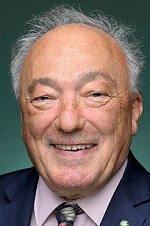
Division of Macarthur is a federal electorate in New South Wales, covering about 307 km². Its federal member is Mike Freelander (Australian Labor Party). State electorates overlapping it include Campbelltown, Leppington, Macquarie Fields, Camden. Local council areas overlapping it include Campbelltown City Council, Camden Council, Liverpool City Council.
- Level
- Federal electorate
- State / territory
- New South Wales (NSW)
- Area
- about 307 km²
- Federal member
- Mike Freelander — Australian Labor Party
- Official source
- AEC electorate profile
On Political Gadgets
State electorates overlapping Macarthur
| Campbelltown (NSW state electorate) | 76% of this federal electorate | 65% of Campbelltown |
| Leppington (NSW state electorate) | 10% of this federal electorate | 23% of Leppington |
| Macquarie Fields (NSW state electorate) | 9% of this federal electorate | 38% of Macquarie Fields |
| Camden (NSW state electorate) | 5% of this federal electorate | 15% of Camden |
Local council areas overlapping Macarthur
| Campbelltown City Council | 91% of this federal electorate | 90% of Campbelltown City Council |
| Camden Council | 6% of this federal electorate | 10% of Camden Council |
| Liverpool City Council | 2% of this federal electorate | 2% of Liverpool City Council |
Suburbs in Macarthur
Suburbs with at least a quarter of their area inside this federal electorate. Select one to see all three levels of electorate.
- Airds 2560
- Ambarvale 2560
- Bardia 2565
- Blair Athol 2560
- Blairmount 2559
- Bow Bowing 2566
- Bradbury 2560
- Campbelltown 2560
- Claymore 2559
- Currans Hill 2567
- Denham Court 2565
- Eagle Vale 2558
- Englorie Park 2560
- Eschol Park 2558
- Gilead 2560
- Gledswood Hills 2557
- Glen Alpine 2563/2560
- Gregory Hills 2557
- Holsworthy 2173
- Kearns 2558
- Kentlyn 2560
- Leumeah 2560
- Menangle Park 2563
- Minto 2566
- Minto Heights 2566
- Raby 2566
- Rosemeadow 2560
- Ruse 2560
- Smeaton Grange 2567
- St Andrews 2566
- St Helens Park 2560
- Varroville 2566
- Wedderburn 2560
- Woodbine 2560
Questions
Who is the federal member for Macarthur?
Mike Freelander of the Australian Labor Party is the federal member for the Division of Macarthur in the House of Representatives.
Which council areas are in the Division of Macarthur?
Council areas overlapping it include Campbelltown City Council, Camden Council, Liverpool City Council.
Which state electorates are in the Division of Macarthur?
State electorates overlapping it include Campbelltown, Leppington, Macquarie Fields, Camden.
Which suburbs are in Macarthur?
Suburbs mostly inside it include Airds, Ambarvale, Blair Athol, Blairmount, Bradbury, Campbelltown, Claymore, Eagle Vale.
How accurate is this?
Boundaries are simplified (about 40 m tolerance), so overlap percentages are approximate. For anything official, such as enrolment or voting, check the Australian Electoral Commission or your state electoral commission.
← All federal electorates · Find My Electorates
Federal boundaries: Australian Electoral Commission (as at the 2025 federal election). State and council boundaries: incorporates or developed using Administrative Boundaries © Geoscape Australia licensed under CC BY 4.0.