Division of Hunter
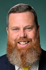
Division of Hunter is a federal electorate in New South Wales, covering about 7,309 km². Its federal member is Dan Repacholi (Australian Labor Party). State electorates overlapping it include Upper Hunter, Cessnock, Lake Macquarie. Local council areas overlapping it include Singleton Council, Cessnock City Council, Lake Macquarie City Council.
- Level
- Federal electorate
- State / territory
- New South Wales (NSW)
- Area
- about 7,309 km²
- Federal member
- Dan Repacholi — Australian Labor Party
- Official source
- AEC electorate profile
On Political Gadgets
State electorates overlapping Hunter
| Upper Hunter (NSW state electorate) | 67% of this federal electorate | 21% of Upper Hunter |
| Cessnock (NSW state electorate) | 26% of this federal electorate | 94% of Cessnock |
| Lake Macquarie (NSW state electorate) | 7% of this federal electorate | 97% of Lake Macquarie |
Local council areas overlapping Hunter
| Singleton Council | 67% of this federal electorate | >99% of Singleton Council |
| Cessnock City Council | 25% of this federal electorate | 94% of Cessnock City Council |
| Lake Macquarie City Council | 8% of this federal electorate | 74% of Lake Macquarie City Council |
Suburbs in Hunter
Suburbs with at least a quarter of their area inside this federal electorate. Select one to see all three levels of electorate.
- Aberdare 2325
- Abermain 2326
- Abernethy 2325
- Allandale 2320
- Appletree Flat 2330
- Arcadia Vale 2283
- Awaba 2283
- Balcolyn 2264
- Balmoral (Lake Macquarie) 2283
- Barnsley 2278
- Belford 2335
- Bellbird 2325
- Bellbird Heights 2325
- Big Ridge 2330
- Blackalls Park 2283
- Bolton Point 2283
- Bonnells Bay 2264
- Booragul 2284
- Bowmans Creek 2330
- Branxton 2335
- Bridgman 2330
- Brightwaters 2264
- Broke 2330
- Brunkerville 2323
- Buchanan 2323
- Bucketty 2250
- Bulga 2330
- Buttaba 2283
- Camberwell 2330
- Cameron Park 2285
- Carey Bay 2283
- Carrowbrook 2330
- Cedar Creek (Cessnock) 2325
- Cessnock 2325
- Clydesdale 2330
- Coal Point 2283
- Congewai 2325
- Cooranbong 2265
- Corrabare 2325
- Dairy Arm 2325
- Dalwood (Singleton) 2335
- Darlington (Singleton) 2330
- Dora Creek 2264
- Doyles Creek 2330
- Dunolly 2330
- Dural (Singleton) 2330
- Dyrring 2330
- East Branxton 2335
- Edgeworth 2285
- Elderslie (Singleton) 2335
- Ellalong 2325
- Elrington 2325
- Eraring 2264
- Falbrook 2330
- Fassifern 2283
- Fennell Bay 2283
- Fern Gully 2330
- Fernances Crossing 2325
- Fishing Point 2283
- Fordwich 2330
- Freemans Waterhole 2323
- Garland Valley 2330
- Glendon 2330
- Glendon Brook 2330
- Glennies Creek 2330
- Glenridding 2330
- Goorangoola 2330
- Gouldsville 2330
- Gowrie (Singleton) 2330
- Greenlands (Singleton) 2330
- Greta 2334
- Greta Main 2325
- Hambledon Hill 2330
- Hebden 2330
- Holmesville 2286
- Howes Valley 2330
- Howick 2330
- Hunterview 2330
- Jerrys Plains 2330
- Kearsley 2325
- Keinbah 2320
- Kilaben Bay 2283
- Killingworth 2278
- Kitchener 2325
- Kurri Kurri 2327
- Laguna 2325
- Lambs Valley (Singleton) 2335
- Leconfield 2335
- Lemington 2330
- Liddell 2333
- Long Point (Singleton) 2330
- Lovedale 2325
- Lower Belford 2335
- Maison Dieu 2330
- Mandalong 2264
- Marmong Point 2284
- Martinsville 2265
- McDougalls Hill 2330
- Middle Falbrook 2330
- Milbrodale 2330
- Millfield 2325
- Mirannie 2330
- Mirrabooka 2264
- Mitchells Flat 2330
- Morisset 2264
- Morisset Park 2264
- Mount Olive (Singleton) 2330
- Mount Royal 2330
- Mount Thorley 2330
- Mount View 2325
- Mount Vincent 2323
- Mulbring 2323
- Murrays Run 2325
- Myuna Bay 2264
- Neath 2326
- North Rothbury 2335
- Nulkaba 2325
- Obanvale 2330
- Olney 2325
- Paxton 2325
- Paynes Crossing 2325
- Pelaw Main 2327
- Pelton 2325
- Pokolbin 2320
- Putty 2330
- Quorrobolong 2325
- Rathmines 2283
- Ravensworth 2330
- Redbournberry 2330
- Reedy Creek 2330
- Richmond Vale 2323
- Rixs Creek 2330
- Rothbury 2320
- Roughit 2330
- Ryhope 2283
- Sawyers Gully 2326
- Scotts Flat 2330
- Seahampton 2286
- Sedgefield 2330
- Silverwater (Lake Macquarie) 2264
- Singleton 2330
- Singleton Heights 2330
- Singleton Military Area 2331
- St Clair (Singleton) 2330
- Stanford Merthyr 2327
- Stanhope 2335
- Sunshine 2264
- Sweetmans Creek 2325
- Teralba 2284
- Toronto 2283
- Wakefield 2278
- Wangi Wangi 2267
- Warkworth 2330
- Watagan 2325
- Wattle Ponds 2330
- West Wallsend 2286
- Westbrook 2330
- Weston 2326
- Whittingham 2330
- Windermere Park 2264
- Wollemi 2330
- Wollombi 2325
- Woodrising 2284
- Wyee 2259
- Wyee Point 2259
- Wylies Flat 2330
- Yarrawonga Park 2264
- Yengo National Park 2325
Questions
Who is the federal member for Hunter?
Dan Repacholi of the Australian Labor Party is the federal member for the Division of Hunter in the House of Representatives.
Which council areas are in the Division of Hunter?
Council areas overlapping it include Singleton Council, Cessnock City Council, Lake Macquarie City Council.
Which state electorates are in the Division of Hunter?
State electorates overlapping it include Upper Hunter, Cessnock, Lake Macquarie.
Which suburbs are in Hunter?
Suburbs mostly inside it include Aberdare, Abermain, Abernethy, Arcadia Vale, Awaba, Balcolyn, Balmoral (Lake Macquarie), Barnsley.
How accurate is this?
Boundaries are simplified (about 40 m tolerance), so overlap percentages are approximate. For anything official, such as enrolment or voting, check the Australian Electoral Commission or your state electoral commission.
← All federal electorates · Find My Electorates
Federal boundaries: Australian Electoral Commission (as at the 2025 federal election). State and council boundaries: incorporates or developed using Administrative Boundaries © Geoscape Australia licensed under CC BY 4.0.