Division of Hinkler
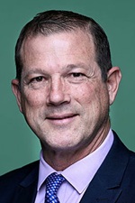
Division of Hinkler is a federal electorate in Queensland, covering about 7,596 km². Its federal member is David Batt (Liberal National Party). State electorates overlapping it include Burnett, Maryborough, Hervey Bay, Bundaberg. Local council areas overlapping it include Bundaberg Regional, Fraser Coast Regional.
- Level
- Federal electorate
- State / territory
- Queensland (QLD)
- Area
- about 7,596 km²
- Federal member
- David Batt — Liberal National Party
- Role
- Deputy Nationals Whip
- Official source
- AEC electorate profile
On Political Gadgets
State electorates overlapping Hinkler
| Burnett (QLD state electorate) | 73% of this federal electorate | 19% of Burnett |
| Maryborough (QLD state electorate) | 16% of this federal electorate | 25% of Maryborough |
| Hervey Bay (QLD state electorate) | 9% of this federal electorate | 28% of Hervey Bay |
| Bundaberg (QLD state electorate) | 1% of this federal electorate | >99% of Bundaberg |
Local council areas overlapping Hinkler
| Bundaberg Regional | 75% of this federal electorate | 46% of Bundaberg Regional |
| Fraser Coast Regional | 25% of this federal electorate | 24% of Fraser Coast Regional |
Suburbs in Hinkler
Suburbs with at least a quarter of their area inside this federal electorate. Select one to see all three levels of electorate.
- Abington 4660
- Alloway 4670
- Apple Tree Creek 4660
- Ashfield 4670
- Avenell Heights 4670
- Avoca 4670
- Bargara 4670
- Beelbi Creek 4659
- Booral 4655
- Booyal 4671
- Branyan 4670
- Bundaberg Central 4670
- Bundaberg East 4670
- Bundaberg North 4670
- Bundaberg South 4670
- Bundaberg West 4670
- Bunya Creek 4655
- Burgowan 4659
- Burnett Heads 4670
- Burrum Heads 4659
- Burrum River 4659
- Burrum Town 4659
- Buxton 4660
- Calavos 4670
- Cherwell 4660
- Childers 4660
- Coonarr 4670
- Coral Cove 4670
- Cordalba 4660
- Craignish 4655
- Doolbi 4660
- Duckinwilla 4650
- Duingal 4671
- Dundathu 4650
- Dundowran 4655
- Dundowran Beach 4655
- Electra 4670
- Eli Waters 4655
- Elliott 4670
- Elliott Heads 4670
- Eureka 4660
- Farnsfield 4660
- Givelda 4670
- Goodwood 4660
- Gregory River (Bundaberg - Qld) 4660
- Horton 4660
- Howard 4659
- Innes Park 4670
- Isis Central 4660
- Isis River 4660
- Kalkie 4670
- Kawungan 4655
- Kensington 4670
- Kepnock 4670
- Kinkuna 4670
- Kullogum 4660
- Millbank 4670
- Mon Repos 4670
- Nikenbah 4655
- North Gregory 4660
- North Isis 4660
- Norville 4670
- Pacific Haven 4659
- Pialba 4655
- Pine Creek 4670
- Point Vernon 4655
- Prawle 4650
- Promisedland 4660
- Qunaba 4670
- Redridge 4660
- River Heads 4655
- Rubyanna 4670
- Scarness 4655
- South Bingera 4670
- South Isis 4660
- Sunshine Acres 4655
- Susan River 4655
- Svensson Heights 4670
- Takura 4655
- Tandora 4650
- Thabeban 4670
- Toogoom 4655
- Torbanlea 4662
- Torquay 4655
- Urangan 4655
- Urraween 4655
- Walkervale 4670
- Walliebum 4650
- Walligan 4655
- Windermere 4670
- Wondunna 4655
- Woodgate 4660
- Woongarra 4670
Questions
Who is the federal member for Hinkler?
David Batt of the Liberal National Party is the federal member for the Division of Hinkler in the House of Representatives.
Which council areas are in the Division of Hinkler?
Council areas overlapping it include Bundaberg Regional, Fraser Coast Regional.
Which state electorates are in the Division of Hinkler?
State electorates overlapping it include Burnett, Maryborough, Hervey Bay, Bundaberg.
Which suburbs are in Hinkler?
Suburbs mostly inside it include Abington, Alloway, Apple Tree Creek, Ashfield, Avenell Heights, Bargara, Beelbi Creek, Booral.
How accurate is this?
Boundaries are simplified (about 40 m tolerance), so overlap percentages are approximate. For anything official, such as enrolment or voting, check the Australian Electoral Commission or your state electoral commission.
← All federal electorates · Find My Electorates
Federal boundaries: Australian Electoral Commission (as at the 2025 federal election). State and council boundaries: incorporates or developed using Administrative Boundaries © Geoscape Australia licensed under CC BY 4.0.