Division of Gilmore
Division of Gilmore is a federal electorate in New South Wales, covering about 6,323 km². Its federal member is Fiona Phillips (Australian Labor Party). State electorates overlapping it include South Coast, Kiama, Bega. Local council areas overlapping it include Shoalhaven City Council, Eurobodalla Shire Council, The Council of the Municipality of Kiama.
- Level
- Federal electorate
- State / territory
- New South Wales (NSW)
- Area
- about 6,323 km²
- Federal member
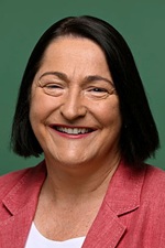
- Fiona Phillips — Australian Labor Party
- Official source
- AEC electorate profile
On Political Gadgets
State electorates overlapping Gilmore
| South Coast (NSW state electorate) | 42% of this federal electorate | 96% of South Coast |
| Kiama (NSW state electorate) | 34% of this federal electorate | 94% of Kiama |
| Bega (NSW state electorate) | 24% of this federal electorate | 15% of Bega |
Local council areas overlapping Gilmore
| Shoalhaven City Council | 72% of this federal electorate | 97% of Shoalhaven City Council |
| Eurobodalla Shire Council | 24% of this federal electorate | 44% of Eurobodalla Shire Council |
| The Council of the Municipality of Kiama | 4% of this federal electorate | >99% of The Council of the Municipality of Kiama |
Suburbs in Gilmore
Suburbs with at least a quarter of their area inside this federal electorate. Select one to see all three levels of electorate.
- Back Forest 2535
- Bamarang 2540
- Bangalee 2541
- Barren Grounds 2577
- Barrengarry 2577
- Barringella 2540
- Basin View 2540
- Batehaven 2536
- Batemans Bay 2536
- Bawley Point 2539
- Beaumont 2577
- Beecroft Peninsula 2540
- Bellawongarah 2535
- Benandarah 2536
- Bendalong 2539
- Bergalia 2537
- Berrara 2540
- Berringer Lake 2539
- Berry 2535
- Berry Mountain 2535
- Bewong 2540
- Bimbimbie 2536
- Bingie 2537
- Bolong 2540
- Bomaderry 2541
- Bombo 2533
- Boolijah 2540
- Bream Beach 2540
- Brogers Creek 2535
- Brooman 2538
- Broughton 2535
- Broughton Vale 2535
- Broughton Village 2534
- Broulee 2537
- Browns Mountain 2540
- Brundee 2540
- Buangla 2540
- Buckenbowra 2536
- Budawang 2622
- Budderoo 2535
- Budgong 2577
- Bulee 2622
- Bundewallah 2535
- Burrier 2540
- Burrill Lake 2539
- Callala Bay 2540
- Callala Beach 2540
- Cambewarra 2540
- Cambewarra Village 2540
- Carrington Falls 2577
- Catalina 2536
- Cockwhy 2539
- Coila 2537
- Comberton 2540
- Comerong Island 2540
- Congo 2537
- Conjola 2539
- Conjola Park 2539
- Coolangatta 2535
- Coolumburra 2622
- Croobyar 2539
- Cudmirrah 2540
- Culburra Beach 2540
- Cunjurong Point 2539
- Curramore 2533
- Currarong 2540
- Currowan 2536
- Denhams Beach 2536
- Depot Beach 2536
- Deua River Valley 2537
- Dolphin Point 2539
- Durras North 2536
- East Lynne 2536
- Endrick 2622
- Erowal Bay 2540
- Ettrema 2540
- Falls Creek 2540
- Far Meadow 2535
- Fishermans Paradise 2539
- Foxground 2534
- Gerringong 2534
- Gerroa 2534
- Greenwell Point 2540
- Guerilla Bay 2536
- Huskisson 2540
- Hyams Beach 2540
- Illaroo 2540
- Jamberoo 2533
- Jaspers Brush 2535
- Jeremadra 2536
- Jerrara 2533
- Jerrawangala 2540
- Kangaroo Valley 2577
- Kiama 2533
- Kiama Downs 2533
- Kiama Heights 2533
- Kinghorne 2540
- Kings Point 2539
- Kioloa 2539
- Kiora 2537
- Knights Hill 2577
- Lake Conjola 2539
- Lake Tabourie 2539
- Lilli Pilli (Eurobodalla) 2536
- Little Forest 2538
- Long Beach 2536
- Longreach 2540
- Maloneys Beach 2536
- Malua Bay 2536
- Manyana 2539
- Mayfield (Shoalhaven) 2540
- Meringo 2537
- Meroo Meadow 2540
- Merricumbene 2622
- Milton 2538
- Minnamurra 2533
- Mogendoura 2537
- Mogo (Eurobodalla) 2536
- Mogood 2538
- Mollymook 2539
- Mollymook Beach 2539
- Mondayong 2540
- Moollattoo 2540
- Morton 2538
- Moruya 2537
- Moruya Heads 2537
- Mossy Point 2537
- Mount Kingiman 2539
- Mundamia 2540
- Murrengenburg 2622
- Myola 2540
- Narrawallee 2539
- Nelligen 2536
- North Batemans Bay 2536
- North Nowra 2541
- Nowra 2541
- Nowra Hill 2540
- Numbaa 2540
- Old Erowal Bay 2540
- Orient Point 2540
- Parma 2540
- Pebbly Beach 2536
- Pointer Mountain 2539
- Porters Creek 2538
- Pretty Beach (Shoalhaven) 2539
- Pyree 2540
- Quiera 2622
- Red Rocks 2577
- Rose Valley (Kiama) 2534
- Rosedale 2536
- Runnyford 2536
- Saddleback Mountain 2533
- Sanctuary Point 2540
- Sassafras 2622
- Shoalhaven Heads 2535
- South Durras 2536
- South Nowra 2541
- St George 2622
- St Georges Basin 2540
- Sunshine Bay 2536
- Surf Beach 2536
- Surfside 2536
- Sussex Inlet 2540
- Swanhaven 2540
- Tallowal 2540
- Tapitallee 2540
- Terara 2540
- Termeil 2539
- Tianjara 2622
- Tolwong 2622
- Tomakin 2537
- Tomerong 2540
- Toolijooa 2534
- Touga 2622
- Tullarwalla 2540
- Tuross Head 2537
- Twelve Mile Peg 2540
- Ulladulla 2539
- Upper Kangaroo River 2577
- Upper Kangaroo Valley 2577
- Vincentia 2540
- Wamban 2537
- Wandandian 2540
- Watersleigh 2540
- Wattamolla 2535
- Werri Beach 2534
- West Nowra 2541
- Willow Vale (Kiama) 2534
- Wollumboola 2540
- Woodburn (Shoalhaven) 2538
- Woodhill 2535
- Woodlands (Eurobodalla) 2536
- Woodstock (Shoalhaven) 2538
- Woollamia 2540
- Worrigee 2540
- Worrowing Heights 2540
- Wrights Beach 2540
- Yadboro 2539
- Yalwal 2540
- Yatte Yattah 2539
- Yellow Rock (Shellharbour) 2527
- Yerriyong 2540
Questions
Who is the federal member for Gilmore?
Fiona Phillips of the Australian Labor Party is the federal member for the Division of Gilmore in the House of Representatives.
Which council areas are in the Division of Gilmore?
Council areas overlapping it include Shoalhaven City Council, Eurobodalla Shire Council, The Council of the Municipality of Kiama.
Which state electorates are in the Division of Gilmore?
State electorates overlapping it include South Coast, Kiama, Bega.
Which suburbs are in Gilmore?
Suburbs mostly inside it include Back Forest, Bamarang, Bangalee, Barren Grounds, Barringella, Basin View, Beaumont, Bellawongarah.
How accurate is this?
Boundaries are simplified (about 40 m tolerance), so overlap percentages are approximate. For anything official, such as enrolment or voting, check the Australian Electoral Commission or your state electoral commission.
← All federal electorates · Find My Electorates
Federal boundaries: Australian Electoral Commission (as at the 2025 federal election). State and council boundaries: incorporates or developed using Administrative Boundaries © Geoscape Australia licensed under CC BY 4.0.