Division of Durack
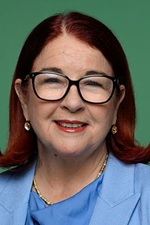
Division of Durack is a federal electorate in Western Australia, covering about 1,410,943 km². Its federal member is Melissa Price (Liberal Party). State electorates overlapping it include Kimberley, Mid-West, Pilbara, Central Wheatbelt. Local council areas overlapping it include Shire of East Pilbara, Shire of Halls Creek, Shire of Derby-West Kimberley, Shire of Wyndham-East Kimberley.
- Level
- Federal electorate
- State / territory
- Western Australia (WA)
- Area
- about 1,410,943 km²
- Federal member
- Melissa Price — Liberal Party
- Official source
- AEC electorate profile
On Political Gadgets
State electorates overlapping Durack
| Kimberley (WA state electorate) | 50% of this federal electorate | 85% of Kimberley |
| Mid-West (WA state electorate) | 29% of this federal electorate | 97% of Mid-West |
| Pilbara (WA state electorate) | 16% of this federal electorate | >99% of Pilbara |
| Central Wheatbelt (WA state electorate) | 3% of this federal electorate | 43% of Central Wheatbelt |
| Geraldton (WA state electorate) | 2% of this federal electorate | >99% of Geraldton |
| Swan Hills (WA state electorate) | <1% of this federal electorate | 32% of Swan Hills |
Local council areas overlapping Durack
| Shire of East Pilbara | 26% of this federal electorate | >99% of Shire of East Pilbara |
| Shire of Halls Creek | 9% of this federal electorate | >99% of Shire of Halls Creek |
| Shire of Derby-West Kimberley | 8% of this federal electorate | 91% of Shire of Derby-West Kimberley |
| Shire of Wyndham-East Kimberley | 8% of this federal electorate | 82% of Shire of Wyndham-East Kimberley |
| Shire of Ashburton | 7% of this federal electorate | 93% of Shire of Ashburton |
| Shire of Meekatharra | 7% of this federal electorate | >99% of Shire of Meekatharra |
| Shire of Upper Gascoyne | 4% of this federal electorate | >99% of Shire of Upper Gascoyne |
| Shire of Broome | 4% of this federal electorate | 85% of Shire of Broome |
| Shire of Carnarvon | 3% of this federal electorate | 84% of Shire of Carnarvon |
| Shire of Murchison | 3% of this federal electorate | >99% of Shire of Murchison |
| Shire of Sandstone | 2% of this federal electorate | >99% of Shire of Sandstone |
| Shire of Yalgoo | 2% of this federal electorate | >99% of Shire of Yalgoo |
| Shire of Shark Bay | 2% of this federal electorate | 72% of Shire of Shark Bay |
| Town of Port Hedland | 1% of this federal electorate | 88% of Town of Port Hedland |
| City of Karratha | 1% of this federal electorate | 59% of City of Karratha |
| Shire of Mount Magnet | <1% of this federal electorate | >99% of Shire of Mount Magnet |
| Shire of Cue | <1% of this federal electorate | >99% of Shire of Cue |
| Shire of Northampton | <1% of this federal electorate | 93% of Shire of Northampton |
| Shire of Mount Marshall | <1% of this federal electorate | >99% of Shire of Mount Marshall |
| City of Greater Geraldton | <1% of this federal electorate | 80% of City of Greater Geraldton |
| Shire of Perenjori | <1% of this federal electorate | >99% of Shire of Perenjori |
| Shire of Dalwallinu | <1% of this federal electorate | >99% of Shire of Dalwallinu |
| Shire of Dandaragan | <1% of this federal electorate | 89% of Shire of Dandaragan |
| Shire of Exmouth | <1% of this federal electorate | 64% of Shire of Exmouth |
| Shire of Coorow | <1% of this federal electorate | 95% of Shire of Coorow |
| Shire of Chapman Valley | <1% of this federal electorate | >99% of Shire of Chapman Valley |
| Shire of Moora | <1% of this federal electorate | >99% of Shire of Moora |
| Shire of Morawa | <1% of this federal electorate | >99% of Shire of Morawa |
| Shire of Mukinbudin | <1% of this federal electorate | >99% of Shire of Mukinbudin |
| Shire of Wongan-Ballidu | <1% of this federal electorate | >99% of Shire of Wongan-Ballidu |
Suburbs in Durack
Suburbs with at least a quarter of their area inside this federal electorate. Select one to see all three levels of electorate.
- Ajana 6532
- Allanooka 6525
- Alma 6535
- Ambania 6632
- Angelo River 6642
- Arrino 6519
- Arrowsmith East 6519
- Baandee 6412
- Badgerin Rock 6475
- Badgingarra 6521
- Ballidu 6606
- Bambun 6503
- Barbalin 6479
- Barberton 6510
- Baynton 6714
- Beacon 6472
- Beermullah 6503
- Bencubbin 6477
- Benjaberring 6463
- Berkshire Valley 6510
- Bilingurr 6725
- Bimbijy 6472
- Bindi Bindi 6574
- Bindoon 6502
- Binnu 6532
- Bonnie Rock 6479
- Boonanarring 6503
- Booralaming 6475
- Bootenal 6532
- Boothendarra 6521
- Bowgada 6623
- Breera 6503
- Breton Bay 6043
- Bringo 6532
- Brown Range 6701
- Bundanoon 6522
- Bunjil 6620
- Buntine 6613
- Burakin 6467
- Burma Road 6532
- Burracoppin 6421
- Burran Rock 6490
- Cadoux 6466
- Calingiri 6569
- Camballin 6728
- Cane 6710
- Canna 6627
- Capricorn 6642
- Carani 6569
- Carnamah 6517
- Carnarvon 6701
- Cataby 6507
- Chandler 6490
- Chichester 6751
- Chittering 6084
- Cleary 6472
- Coburn 6532
- Cooladar Hill 6638
- Coolcalalaya 6532
- Cooljarloo 6507
- Coomberdale 6512
- Coonabidgee 6503
- Coorow 6515
- Cooya Pooya 6714
- Cowalla 6503
- Cowcowing 6485
- Cue 6640
- Cullalla 6503
- Cunderdin 6407
- Cunjardine 6401
- Daadenning Creek 6410
- Daggar Hills 6638
- Dalwallinu 6609
- Dandanning 6479
- Dandaragan 6507
- Dartmoor 6532
- Deepdale 6532
- Devils Creek 6630
- Dindiloa 6532
- Djugun 6725
- Doodlakine 6411
- Dowerin 6461
- Dudawa 6519
- Dukin 6475
- Durack 6743
- Durawah 6532
- East Ballidu 6606
- East Bowes 6535
- East Chapman 6532
- East Damboring 6608
- East Lyons River 6705
- East Murchison 6640
- East Nabawa 6532
- East Yuna 6532
- Eganu 6515
- Elabbin 6490
- Ellendale 6532
- Eneabba 6518
- Eradu 6532
- Eradu South 6532
- Eurardy 6532
- Fitzroy Crossing 6765
- Fortescue 6716
- Gabalong 6574
- Gabbin 6476
- Gascoyne Junction 6705
- Gascoyne River 6705
- Geegully Creek 6728
- Georgina 6532
- Gibb 6743
- Gibson Desert North 0872
- Gillingarra 6510
- Gilroyd 6701
- Gingerah 6725
- Gingin 6503
- Ginginup 6503
- Glentromie 6509
- Goodlands 6468
- Goomalling 6460
- Goomarin 6415
- Granville 6503
- Greenwoods Valley 6405
- Greys Plain 6701
- Gunyidi 6513
- Gutha 6623
- Halls Creek 6770
- Hamelin Pool 6532
- Hamersley Range 6716
- Hill River 6521
- Hindmarsh 6462
- Hines Hill 6413
- Holmwood 6522
- Howatharra 6532
- Hulongine 6460
- Ikewa 6522
- Indee 6721
- Inggarda 6701
- Innawanga 6751
- Irwin 6525
- Isseka 6535
- Jarlmadangah Burru 6728
- Jennacubbine 6401
- Jibberding 6612
- Jigalong 6753
- Juna Downs 6751
- Kadathinni 6519
- Kalannie 6468
- Kalbarri National Park 6536
- Kalumburu 6740
- Karakin 6044
- Karalundi 6642
- Karijini 6751
- Karloning 6479
- Karloo 6530
- Karratha 6714
- Karratha Industrial Estate 6714
- Karroun Hill 6472
- Kellerberrin 6410
- Kennedy Range 6701
- King Leopold Ranges 6728
- Kojarena 6532
- Kondut 6605
- Konnongorring 6603
- Koojan 6510
- Koolanooka 6623
- Koomberkine 6461
- Koorda 6475
- Korbel 6415
- Korrelocking 6485
- Kulja 6470
- Kumarina 6642
- Kundat Djaru 6770
- Kununoppin 6489
- Kupartiya 6770
- Kwelkan 6490
- Lake Argyle 6743
- Lake Austin 6640
- Lake Brown 6479
- Lake Hinds 6603
- Lake Margarette 6475
- Lake Ninan 6603
- Latham 6616
- Lennard Brook 6503
- Lockier 6522
- Lyndon 6701
- Manmanning 6465
- Marble Bar 6760
- Marchagee 6515
- Marne 6608
- Marrah 6532
- Maya 6614
- McBeath 6770
- Meadow 6532
- Meekatharra 6642
- Merkanooka 6625
- Merredin 6415
- Meru 6530
- Miamoon 6612
- Miling 6575
- Millars Well 6714
- Millstream 6716
- Milo 6525
- Mimegarra 6507
- Mindarra 6503
- Mingenew 6522
- Minilya 6701
- Minnenooka 6532
- Minnivale 6462
- Mocardy 6603
- Mogumber 6506
- Mollerin 6475
- Mooliabeenee 6504
- Moondah 6503
- Moonyoonooka 6532
- Moora 6510
- Moore River National Park 6503
- Mooriary 6522
- Morawa 6623
- Moresby 6530
- Mount Budd 6522
- Mount Caroline 6410
- Mount Erin 6532
- Mount Hardman 6765
- Mount Hill 6528
- Mount Horner 6525
- Mount Magnet 6638
- Mount Sheila 6751
- Mount Tarcoola 6530
- Mouroubra 6472
- Muckenburra 6503
- Mueller Ranges 6770
- Mukinbudin 6479
- Mulga Downs 6751
- Mullewa 6630
- Murchison 6630
- Nabawa 6532
- Nalkain 6485
- Namban 6512
- Nangeenan 6414
- Nangetty 6522
- Nanson 6532
- Nanutarra 6751
- Naraling 6532
- Narngulu 6532
- Narra Tarra 6532
- Neergabby 6503
- Nembudding 6485
- Nerramyne 6630
- Nerren Nerren 6532
- New Norcia 6509
Showing 250 of 533 suburbs.
Questions
Who is the federal member for Durack?
Melissa Price of the Liberal Party is the federal member for the Division of Durack in the House of Representatives.
Which council areas are in the Division of Durack?
Council areas overlapping it include Shire of East Pilbara, Shire of Halls Creek, Shire of Derby-West Kimberley, Shire of Wyndham-East Kimberley, Shire of Ashburton, Shire of Meekatharra.
Which state electorates are in the Division of Durack?
State electorates overlapping it include Kimberley, Mid-West, Pilbara, Central Wheatbelt, Geraldton, Swan Hills.
Which suburbs are in Durack?
Suburbs mostly inside it include Ajana, Allanooka, Alma, Ambania, Angelo River, Arrino, Arrowsmith East, Baandee.
How accurate is this?
Boundaries are simplified (about 40 m tolerance), so overlap percentages are approximate. For anything official, such as enrolment or voting, check the Australian Electoral Commission or your state electoral commission.
← All federal electorates · Find My Electorates
Federal boundaries: Australian Electoral Commission (as at the 2025 federal election). State and council boundaries: incorporates or developed using Administrative Boundaries © Geoscape Australia licensed under CC BY 4.0.