Division of Dawson
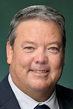
Division of Dawson is a federal electorate in Queensland, covering about 67,378 km². Its federal member is Andrew Willcox (Liberal National Party). State electorates overlapping it include Whitsunday, Burdekin, Mirani, Mackay. Local council areas overlapping it include Mackay Regional, Whitsunday Regional, Burdekin Shire.
- Level
- Federal electorate
- State / territory
- Queensland (QLD)
- Area
- about 67,378 km²
- Federal member
- Andrew Willcox — Liberal National Party
- Official source
- AEC electorate profile
On Political Gadgets
State electorates overlapping Dawson
| Whitsunday (QLD state electorate) | 48% of this federal electorate | >99% of Whitsunday |
| Burdekin (QLD state electorate) | 41% of this federal electorate | 28% of Burdekin |
| Mirani (QLD state electorate) | 11% of this federal electorate | 10% of Mirani |
| Mackay (QLD state electorate) | <1% of this federal electorate | >99% of Mackay |
| Mundingburra (QLD state electorate) | <1% of this federal electorate | 63% of Mundingburra |
Local council areas overlapping Dawson
| Mackay Regional | 41% of this federal electorate | 80% of Mackay Regional |
| Whitsunday Regional | 38% of this federal electorate | 63% of Whitsunday Regional |
| Burdekin Shire | 20% of this federal electorate | 87% of Burdekin Shire |
Suburbs in Dawson
Suburbs with at least a quarter of their area inside this federal electorate. Select one to see all three levels of electorate.
- Airdmillan 4807
- Airlie Beach 4802
- Airville 4807
- Alligator Creek (Townsville - Qld) 4816
- Alva 4807
- Andergrove 4740
- Andromache 4800
- Annandale 4814
- Ayr 4807
- Ball Bay 4741
- Balnagowan 4740
- Barratta 4809
- Beaconsfield 4740
- Belmunda 4740
- Blacks Beach 4740
- Bloomsbury 4799
- Bogie 4805
- Bowen 4805
- Brandon 4808
- Brandy Creek 4800
- Breadalbane 4800
- Bucasia 4750
- Calen 4798
- Cannon Valley 4800
- Cannonvale 4802
- Cape Cleveland 4810
- Cape Conway 4800
- Cape Gloucester 4800
- Cape Hillsborough 4740
- Carstairs 4806
- Clare 4807
- Cluden 4811
- Colevale 4808
- Conway 4800
- Conway Beach 4800
- Coral Sea 4741/4875
- Cremorne 4740
- Cromarty 4809
- Crystal Brook 4800
- Cungulla 4816
- Dingo Beach 4800
- Dittmer 4800
- Dolphin Heads 4740
- Dumbleton 4740
- East Mackay 4740
- Eimeo 4740
- Erakala 4740
- Farleigh 4741
- Flametree 4802
- Foulden 4740
- Foxdale 4800
- Fredericksfield 4806
- Giru 4809
- Glen Isla 4800
- Glenella 4740
- Goorganga Creek 4800
- Goorganga Plains 4800
- Gregory River (Whitsunday - Qld) 4800
- Groper Creek 4806
- Gumlu 4805
- Gunyarra 4800
- Guthalungra 4805
- Habana 4740
- Haliday Bay 4740
- Hamilton Plains 4800
- Hampden 4741
- Hideaway Bay 4800
- Home Hill 4806
- Horseshoe Lagoon 4809
- Idalia 4811
- Inkerman 4806
- Jarvisfield 4807
- Jerona 4809
- Jubilee Pocket 4802
- Julago 4816
- Kelsey Creek 4800
- Kirknie 4806
- Kuttabul 4741
- Laguna Quays 4800
- Lake Proserpine 4800
- Lethebrook 4800
- Mackay 4740
- Mackay Harbour 4740
- Majors Creek 4816
- Mandalay 4802
- McDesme 4807
- Mentmore 4798
- Midge Point 4799
- Mona Park 4807
- Mount Charlton 4741
- Mount Jukes 4740
- Mount Julian 4800
- Mount Kelly 4807
- Mount Marlow 4800
- Mount Ossa 4741
- Mount Pelion 4741
- Mount Pleasant (Mackay - Qld) 4740
- Mount Pluto 4800
- Mount Rooper 4802
- Mount Surround 4809
- Myrtlevale 4800
- Nindaroo 4740
- Nome 4816
- North Mackay 4740
- Oonoonba 4811
- Osborne 4806
- Paget 4740
- Palm Grove 4800
- Pauls Pocket 4800
- Pindi Pindi 4798
- Preston (Whitsunday - Qld) 4800
- Proserpine 4800
- Rangemore (Burdekin - Qld) 4806
- Richmond (Mackay - Qld) 4740
- Riordanvale 4800
- Rita Island 4807
- Rural View 4740
- Seaforth 4741
- Shirbourne 4809
- Shoal Point 4750
- Shute Harbour 4802
- Silver Creek 4800
- Slade Point 4740
- South Mackay 4740
- St Helens Beach 4798
- Strathdickie 4800
- Stuart 4811
- Sugarloaf (Whitsunday - Qld) 4800
- The Leap 4740
- Thoopara 4800
- Upper Haughton 4809
- Wangaratta 4806
- West Mackay 4740
- Whitsundays 4802
- Wilson Beach 4800
- Woodwark 4802
- Wulguru 4811
- Wunjunga 4806
- Yalboroo 4741
Questions
Who is the federal member for Dawson?
Andrew Willcox of the Liberal National Party is the federal member for the Division of Dawson in the House of Representatives.
Which council areas are in the Division of Dawson?
Council areas overlapping it include Mackay Regional, Whitsunday Regional, Burdekin Shire.
Which state electorates are in the Division of Dawson?
State electorates overlapping it include Whitsunday, Burdekin, Mirani, Mackay, Mundingburra.
Which suburbs are in Dawson?
Suburbs mostly inside it include Airdmillan, Airlie Beach, Airville, Alva, Andergrove, Andromache, Ayr, Ball Bay.
How accurate is this?
Boundaries are simplified (about 40 m tolerance), so overlap percentages are approximate. For anything official, such as enrolment or voting, check the Australian Electoral Commission or your state electoral commission.
← All federal electorates · Find My Electorates
Federal boundaries: Australian Electoral Commission (as at the 2025 federal election). State and council boundaries: incorporates or developed using Administrative Boundaries © Geoscape Australia licensed under CC BY 4.0.