Division of Canning
Division of Canning is a federal electorate in Western Australia, covering about 3,739 km². Its federal member is Andrew Hastie (Liberal Party). State electorates overlapping it include Murray-Wellington, Darling Range, Dawesville, Secret Harbour. Local council areas overlapping it include Shire of Murray, Shire of Serpentine-Jarrahdale, Shire of Waroona, City of Mandurah.
- Level
- Federal electorate
- State / territory
- Western Australia (WA)
- Area
- about 3,739 km²
- Federal member
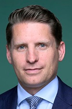
- Andrew Hastie — Liberal Party
- Official source
- AEC electorate profile
On Political Gadgets
State electorates overlapping Canning
| Murray-Wellington (WA state electorate) | 70% of this federal electorate | 60% of Murray-Wellington |
| Darling Range (WA state electorate) | 23% of this federal electorate | 62% of Darling Range |
| Dawesville (WA state electorate) | 4% of this federal electorate | >99% of Dawesville |
| Secret Harbour (WA state electorate) | 1% of this federal electorate | 72% of Secret Harbour |
| Mandurah (WA state electorate) | 1% of this federal electorate | >99% of Mandurah |
Local council areas overlapping Canning
| Shire of Murray | 48% of this federal electorate | >99% of Shire of Murray |
| Shire of Serpentine-Jarrahdale | 22% of this federal electorate | 92% of Shire of Serpentine-Jarrahdale |
| Shire of Waroona | 22% of this federal electorate | >99% of Shire of Waroona |
| City of Mandurah | 6% of this federal electorate | >99% of City of Mandurah |
| City of Rockingham | 2% of this federal electorate | 27% of City of Rockingham |
Suburbs in Canning
Suburbs with at least a quarter of their area inside this federal electorate. Select one to see all three levels of electorate.
- Banksiadale 6213
- Barragup 6209
- Birchmont 6214
- Blythewood 6208
- Bouvard 6211
- Byford 6122
- Cardup 6122
- Clifton 6211
- Coodanup 6210
- Coolup 6214
- Dawesville 6211
- Dudley Park 6210
- Dwellingup 6213
- Erskine 6210
- Etmilyn 6213
- Fairbridge 6208
- Falcon 6210
- Furnissdale 6209
- Golden Bay 6174
- Greenfields 6210
- Halls Head 6210
- Hamel 6215
- Herron 6211
- Holyoake 6213
- Hopeland 6125
- Inglehope 6213
- Jarrahdale 6124
- Karnup 6176
- Karrakup 6122
- Keralup 6182
- Keysbrook 6126
- Lake Clifton 6215
- Lakelands 6180
- Madora Bay 6210
- Mandurah 6210
- Mardella 6125
- Marrinup 6213
- Meadow Springs 6210
- Meelon 6208
- Mundijong 6123
- Myara 6207
- Nambeelup 6207
- Nanga Brook 6215
- Nirimba 6208
- North Dandalup 6207
- North Yunderup 6208
- Oldbury 6121
- Parklands 6180
- Pinjarra 6208
- Preston Beach 6215
- Ravenswood 6208
- San Remo 6210
- Secret Harbour 6173
- Serpentine 6125
- Silver Sands 6210
- Singleton 6175
- Solus 6207
- South Yunderup 6208
- Stake Hill 6181
- Teesdale 6213
- Wagerup 6215
- Wannanup 6210
- Waroona 6215
- West Coolup 6214
- West Pinjarra 6208
- Whitby 6123
- Whittaker 6207
Questions
Who is the federal member for Canning?
Andrew Hastie of the Liberal Party is the federal member for the Division of Canning in the House of Representatives.
Which council areas are in the Division of Canning?
Council areas overlapping it include Shire of Murray, Shire of Serpentine-Jarrahdale, Shire of Waroona, City of Mandurah, City of Rockingham.
Which state electorates are in the Division of Canning?
State electorates overlapping it include Murray-Wellington, Darling Range, Dawesville, Secret Harbour, Mandurah.
Which suburbs are in Canning?
Suburbs mostly inside it include Barragup, Birchmont, Blythewood, Clifton, Coodanup, Coolup, Dudley Park, Dwellingup.
How accurate is this?
Boundaries are simplified (about 40 m tolerance), so overlap percentages are approximate. For anything official, such as enrolment or voting, check the Australian Electoral Commission or your state electoral commission.
← All federal electorates · Find My Electorates
Federal boundaries: Australian Electoral Commission (as at the 2025 federal election). State and council boundaries: incorporates or developed using Administrative Boundaries © Geoscape Australia licensed under CC BY 4.0.