Division of Bullwinkel
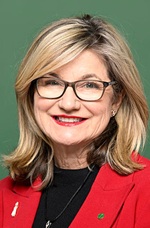
Division of Bullwinkel is a federal electorate in Western Australia, covering about 9,508 km². Its federal member is Trish Cook (Australian Labor Party). State electorates overlapping it include Central Wheatbelt, Kalamunda, Darling Range, Swan Hills. Local council areas overlapping it include Shire of Beverley, Shire of York, Shire of Toodyay, Shire of Northam.
- Level
- Federal electorate
- State / territory
- Western Australia (WA)
- Area
- about 9,508 km²
- Federal member
- Trish Cook — Australian Labor Party
- Official source
- AEC electorate profile
On Political Gadgets
State electorates overlapping Bullwinkel
| Central Wheatbelt (WA state electorate) | 80% of this federal electorate | 8% of Central Wheatbelt |
| Kalamunda (WA state electorate) | 9% of this federal electorate | >99% of Kalamunda |
| Darling Range (WA state electorate) | 5% of this federal electorate | 33% of Darling Range |
| Swan Hills (WA state electorate) | 4% of this federal electorate | 45% of Swan Hills |
| Forrestfield (WA state electorate) | <1% of this federal electorate | 99% of Forrestfield |
| Thornlie (WA state electorate) | <1% of this federal electorate | 61% of Thornlie |
| Midland (WA state electorate) | <1% of this federal electorate | 51% of Midland |
| Armadale (WA state electorate) | <1% of this federal electorate | 40% of Armadale |
Local council areas overlapping Bullwinkel
| Shire of Beverley | 25% of this federal electorate | >99% of Shire of Beverley |
| Shire of York | 22% of this federal electorate | >99% of Shire of York |
| Shire of Toodyay | 18% of this federal electorate | >99% of Shire of Toodyay |
| Shire of Northam | 15% of this federal electorate | >99% of Shire of Northam |
| Shire of Mundaring | 7% of this federal electorate | >99% of Shire of Mundaring |
| City of Armadale | 5% of this federal electorate | 85% of City of Armadale |
| City of Swan | 4% of this federal electorate | 38% of City of Swan |
| City of Kalamunda | 3% of this federal electorate | >99% of City of Kalamunda |
| City of Gosnells | <1% of this federal electorate | 33% of City of Gosnells |
Suburbs in Bullwinkel
Suburbs with at least a quarter of their area inside this federal electorate. Select one to see all three levels of electorate.
- Ashendon 6111
- Avon Valley National Park 6084
- Badgin 6302
- Bailup 6082
- Bakers Hill 6562
- Balladong 6302
- Bally Bally 6304
- Bedfordale 6112
- Beechina 6556
- Bejoording 6566
- Bellevue 6056
- Beverley 6304
- Bickley 6076
- Bindoon Training Area 6502
- Boya 6056
- Buckland 6401
- Burges 6302
- Burlong 6401
- Bushmead 6055
- Caljie 6302
- Canning Mills 6111
- Carmel 6076
- Chidlow 6556
- Clackline 6564
- Cold Harbour 6302
- Coondle 6566
- Copley 6562
- Culham 6566
- Dale 6304
- Daliak 6302
- Darlington 6070
- Dewars Pool 6567
- Dumbarton 6566
- East Beverley 6304
- Flint 6302
- Flynn 6302
- Forrestfield 6058
- Gidgegannup 6083
- Gilgering 6302
- Glen Forrest 6071
- Gooseberry Hill 6076
- Gorrie 6556
- Grass Valley 6403
- Greenhills 6302
- Greenmount 6056
- Gwambygine 6302
- Hacketts Gully 6076
- Hazelmere 6055
- Helena Valley 6056
- High Wycombe 6057
- Hoddys Well 6566
- Hovea 6071
- Inkpen 6302
- Irishtown 6401
- Jane Brook 6056
- Jennapullin 6401
- Julimar 6567
- Kalamunda 6076
- Karragullen 6111
- Katrine 6401
- Kauring 6302
- Kelmscott 6111
- Kokeby 6304
- Koongamia 6056
- Lesley 6111
- Lesmurdie 6076
- Mahogany Creek 6072
- Maida Vale 6057
- Malabaine 6401
- Malebelling 6302
- Malmalling 6556
- Martin 6110
- Meenaar 6401
- Midvale 6056
- Mokine 6401
- Moondyne 6567
- Morangup 6083
- Morbinning 6304
- Mount Hardey 6302
- Mount Helena 6082
- Mount Nasura 6112
- Mount Observation 6302
- Mount Richon 6112
- Muluckine 6401
- Mundaring 6073
- Muresk 6401
- Narraloggan 6302
- Northam 6401
- Nunile 6566
- Orange Grove 6109
- Parkerville 6081
- Paulls Valley 6076
- Pickering Brook 6076
- Piesse Brook 6076
- Quellington 6302
- Reservoir 6076
- Roleystone 6111
- Sawyers Valley 6074
- Southern Brook 6401
- Spencers Brook 6401
- St Ronans 6302
- Stoneville 6081
- Stratton 6056
- Swan View 6056
- Talbot 6302
- Talbot West 6302
- The Lakes 6556
- Throssell 6401
- Toodyay 6566
- Walliston 6076
- Wattening 6568
- Wattle Grove 6107
- West Toodyay 6566
- Westdale 6304
- Wilberforce 6302
- Wooroloo 6558
- Woottating 6562
- Wundowie 6560
- Wungong 6112
- York 6302
Questions
Who is the federal member for Bullwinkel?
Trish Cook of the Australian Labor Party is the federal member for the Division of Bullwinkel in the House of Representatives.
Which council areas are in the Division of Bullwinkel?
Council areas overlapping it include Shire of Beverley, Shire of York, Shire of Toodyay, Shire of Northam, Shire of Mundaring, City of Armadale.
Which state electorates are in the Division of Bullwinkel?
State electorates overlapping it include Central Wheatbelt, Kalamunda, Darling Range, Swan Hills, Forrestfield, Thornlie.
Which suburbs are in Bullwinkel?
Suburbs mostly inside it include Ashendon, Avon Valley National Park, Bailup, Bakers Hill, Balladong, Beechina, Beverley, Bickley.
How accurate is this?
Boundaries are simplified (about 40 m tolerance), so overlap percentages are approximate. For anything official, such as enrolment or voting, check the Australian Electoral Commission or your state electoral commission.
← All federal electorates · Find My Electorates
Federal boundaries: Australian Electoral Commission (as at the 2025 federal election). State and council boundaries: incorporates or developed using Administrative Boundaries © Geoscape Australia licensed under CC BY 4.0.