Division of Berowra
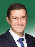
Division of Berowra is a federal electorate in New South Wales, covering about 795 km². Its federal member is Julian Leeser (Liberal Party). State electorates overlapping it include Hornsby, Hawkesbury, Castle Hill, Wahroonga. Local council areas overlapping it include The Council of the Shire of Hornsby, The Hills Shire Council.
- Level
- Federal electorate
- State / territory
- New South Wales (NSW)
- Area
- about 795 km²
- Federal member
- Julian Leeser — Liberal Party
- Official source
- AEC electorate profile
On Political Gadgets
State electorates overlapping Berowra
| Hornsby (NSW state electorate) | 58% of this federal electorate | >99% of Hornsby |
| Hawkesbury (NSW state electorate) | 27% of this federal electorate | 7% of Hawkesbury |
| Castle Hill (NSW state electorate) | 10% of this federal electorate | 71% of Castle Hill |
| Wahroonga (NSW state electorate) | 2% of this federal electorate | 39% of Wahroonga |
| Epping (NSW state electorate) | 2% of this federal electorate | 34% of Epping |
Local council areas overlapping Berowra
| The Council of the Shire of Hornsby | 63% of this federal electorate | >99% of The Council of the Shire of Hornsby |
| The Hills Shire Council | 37% of this federal electorate | 75% of The Hills Shire Council |
Suburbs in Berowra
Suburbs with at least a quarter of their area inside this federal electorate. Select one to see all three levels of electorate.
- Annangrove 2156
- Arcadia 2159
- Asquith 2077
- Beecroft 2119
- Berowra 2081
- Berowra Heights 2082
- Berowra Waters 2082
- Berrilee 2159
- Brooklyn 2083
- Canoelands 2157
- Cattai 2756
- Cheltenham 2119
- Cherrybrook 2126
- Cowan 2081
- Dangar Island 2083
- Dural (Hornsby) 2158
- Epping 2121
- Fiddletown 2159
- Forest Glen 2157
- Galston 2159
- Glenhaven 2156
- Glenorie 2157
- Hornsby 2077
- Hornsby Heights 2077
- Kenthurst 2156
- Laughtondale 2775
- Leets Vale 2775
- Lower Portland 2756
- Maraylya 2765
- Maroota 2756
- Middle Dural 2158
- Milsons Passage 2083
- Mount Colah 2079
- Mount Kuring-Gai 2080
- Normanhurst 2076
- North Epping 2121
- Pennant Hills 2120
- Sackville North 2756
- Singletons Mill 2775
- South Maroota 2756
- Thornleigh 2120
- Waitara 2077
- Westleigh 2120
- Wisemans Ferry 2775
Questions
Who is the federal member for Berowra?
Julian Leeser of the Liberal Party is the federal member for the Division of Berowra in the House of Representatives.
Which council areas are in the Division of Berowra?
Council areas overlapping it include The Council of the Shire of Hornsby, The Hills Shire Council.
Which state electorates are in the Division of Berowra?
State electorates overlapping it include Hornsby, Hawkesbury, Castle Hill, Wahroonga, Epping.
Which suburbs are in Berowra?
Suburbs mostly inside it include Arcadia, Berowra, Berowra Heights, Berowra Waters, Berrilee, Brooklyn, Canoelands, Cheltenham.
How accurate is this?
Boundaries are simplified (about 40 m tolerance), so overlap percentages are approximate. For anything official, such as enrolment or voting, check the Australian Electoral Commission or your state electoral commission.
← All federal electorates · Find My Electorates
Federal boundaries: Australian Electoral Commission (as at the 2025 federal election). State and council boundaries: incorporates or developed using Administrative Boundaries © Geoscape Australia licensed under CC BY 4.0.