Division of Barker
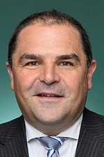
Division of Barker is a federal electorate in South Australia, covering about 65,204 km². Its federal member is Tony Pasin (Liberal Party). State electorates overlapping it include MacKillop, Chaffey, Hammond, Mount Gambier. Local council areas overlapping it include Coorong District Council, The DC of Loxton Waikerie, Tatiara DC, Mid Murray Council.
- Level
- Federal electorate
- State / territory
- South Australia (SA)
- Area
- about 65,204 km²
- Federal member
- Tony Pasin — Liberal Party
- Official source
- AEC electorate profile
On Political Gadgets
State electorates overlapping Barker
| MacKillop (SA state electorate) | 52% of this federal electorate | >99% of MacKillop |
| Chaffey (SA state electorate) | 37% of this federal electorate | 80% of Chaffey |
| Hammond (SA state electorate) | 4% of this federal electorate | 77% of Hammond |
| Mount Gambier (SA state electorate) | 3% of this federal electorate | >99% of Mount Gambier |
| Schubert (SA state electorate) | 3% of this federal electorate | 77% of Schubert |
Local council areas overlapping Barker
| Coorong District Council | 14% of this federal electorate | >99% of Coorong District Council |
| The DC of Loxton Waikerie | 12% of this federal electorate | >99% of The DC of Loxton Waikerie |
| Tatiara DC | 10% of this federal electorate | >99% of Tatiara DC |
| Mid Murray Council | 10% of this federal electorate | >99% of Mid Murray Council |
| Southern Mallee DC | 9% of this federal electorate | >99% of Southern Mallee DC |
| Pastoral Unincorporated Area | 8% of this federal electorate | <1% of Pastoral Unincorporated Area |
| Naracoorte Lucindale Council | 7% of this federal electorate | >99% of Naracoorte Lucindale Council |
| The DC of Karoonda East Murray | 7% of this federal electorate | >99% of The DC of Karoonda East Murray |
| Wattle Range Council | 6% of this federal electorate | >99% of Wattle Range Council |
| Kingston DC | 5% of this federal electorate | >99% of Kingston DC |
| The DC of Grant | 3% of this federal electorate | >99% of The DC of Grant |
| The Rural City of Murray Bridge | 3% of this federal electorate | >99% of The Rural City of Murray Bridge |
| DC of Robe | 2% of this federal electorate | >99% of DC of Robe |
| Light Regional Council | 1% of this federal electorate | 73% of Light Regional Council |
| Renmark Paringa Council | 1% of this federal electorate | >99% of Renmark Paringa Council |
| The Barossa Council | 1% of this federal electorate | 96% of The Barossa Council |
| The Berri Barmera Council | <1% of this federal electorate | >99% of The Berri Barmera Council |
| UIA Riverland | <1% of this federal electorate | >99% of UIA Riverland |
| City of Mount Gambier | <1% of this federal electorate | >99% of City of Mount Gambier |
Suburbs in Barker
Suburbs with at least a quarter of their area inside this federal electorate. Select one to see all three levels of electorate.
- Alawoona 5311
- Allendale East 5291
- Allendale North 5373
- Altona 5351
- Angas Valley 5238
- Angaston 5353
- Annadale 5356
- Apamurra 5237
- Ashville 5259
- Avenue Range 5273
- Avoca Dell 5253
- Bakara 5354
- Bakara Well 5354
- Barmera 5345
- Beatty 5320
- Beaumonts 5320
- Berri 5343
- Bethany 5352
- Big Bend 5238
- Billiatt 5311
- Binnum 5262
- Black Hill 5353
- Blackford 5275
- Blanchetown 5357
- Bolto 5238
- Bookpurnong 5333
- Bool Lagoon 5271
- Boolgun 5330
- Bordertown 5268
- Bordertown South 5268
- Borrika 5309
- Bowhill 5238
- Bray 5276
- Brenda Park 5320
- Brimbago 5267
- Brinkley 5253
- Buckingham 5270
- Bugle Hut 5311
- Bunbury 5266
- Burdett 5253
- Burrungule 5291
- Cadell 5321
- Cadgee 5271
- Caliph 5310
- Caloote 5254
- Calperum Station 5341
- Cambrai 5353
- Cannawigara 5268
- Carcuma 5301
- Carew 5270
- Caroline 5291
- Caurnamont 5238
- Caveton 5291
- Chaffey 5341
- Chapman Bore 5253
- Clay Wells 5280
- Claypans 5238
- Cobdogla 5346
- Cockatoo Valley 5351
- Colebatch 5266
- Coles 5272
- Compton 5291
- Conmurra 5272
- Cooke Plains 5261
- Cooltong 5341
- Coomandook 5261
- Coombe 5267
- Coonalpyn 5265
- Coonawarra 5263
- Copeville 5308
- Cowirra 5238
- Crescent 5341
- Culburra 5261
- Custon 5269
- Daveyston 5355
- Deepwater 5266
- Devlins Pound 5330
- Dismal Swamp 5291
- Eba 5320
- Ebenezer 5355
- Eden Valley 5235
- Elwomple 5260
- Ettrick 5253
- Field 5265
- Fisher 5354
- Five Miles 5238
- Flaxman Valley 5235
- Fords 5373
- Forster 5238
- Fox 5272
- Frahns 5238
- Frances 5262
- Frayville 5238
- Freeling 5372
- Furner 5280
- Galga 5308
- Geranium 5301
- Gerard 5343
- German Creek 5291
- German Flat 5280
- Gifford Hill 5253
- Glencoe 5291
- Glenroy 5277
- Glossop 5344
- Golden Heights 5322
- Gomersal 5352
- Good Hope Landing 5330
- Greenock 5360
- Greenways 5272
- Gurra Gurra 5343
- Halidon 5309
- Hatherleigh 5280
- Holder 5330
- Holder Siding 5330
- Hynam 5262
- Jabuk 5301
- Jervois 5259
- Julanka Holdings 5238
- Kalangadoo 5278
- Kangaroo Inn 5280
- Kanni 5330
- Karoonda 5307
- Katarapko 5343
- Keilira 5275
- Keith 5267
- Kepa 5259
- Keppoch 5271
- Keyneton 5353
- Ki Ki 5261
- Kingston On Murray 5331
- Kongal 5270
- Kongorong 5291
- Koonunga 5373
- Koorine 5279
- Kringin 5304
- Krondorf 5352
- Krongart 5278
- Kybybolite 5262
- Laffer 5267
- Lake Albert 5259
- Lake Carlet 5238
- Lameroo 5302
- Langs Landing 5353
- Light Pass 5355
- Lochaber 5271
- Long Flat 5253
- Loveday 5345
- Lowan Vale 5268
- Lowbank 5330
- Loxton 5333
- Loxton North 5333
- Lucindale 5272
- Lyndoch 5351/5352
- Lyrup 5343
- Maaoupe 5277
- Magarey 5280
- Maggea 5311
- Makin 5267
- Malinong 5259
- Malpas 5311
- Mannum 5238
- Mantung 5308
- Marama 5307
- Marananga 5355
- Marcollat 5271
- Marks Landing 5354
- McBean Pound 5357
- McCallum 5267
- Meningie 5264
- Meningie East 5264
- Meningie West 5264
- Mercunda 5308
- Milendella 5237
- Millicent 5280
- Mindarie 5309
- Mobilong 5253
- Moculta 5353
- Moerlong 5278
- Monarto 5254
- Monash 5342
- Monbulla 5277
- Monteith 5253
- Moorak 5291
- Moorlands 5301
- Moorook 5332
- Moorook South 5332
- Moppa 5355
- Morgan 5320
- Morphetts Flat 5320
- Mount Burr 5279
- Mount Charles 5267
- Mount Gambier 5290
- Mount Light 5271
- Mount Mary 5374
- Mount Mcintyre 5279
- Mount Mckenzie 5353
- Mount Pleasant 5235
- Mount Schank 5291
- Moyhall 5271
- Mulgundawa 5255
- Mundic Creek 5340
- Mundulla 5270
- Mundulla West 5270
- Murbko 5320
- Murrawong 5253
- Murray Bridge 5253
- Murray Bridge East 5253
- Murray Bridge North 5253
- Murray Bridge South 5253
- Mypolonga 5254
- Naidia 5354
- Nain 5360
- Nangwarry 5277
- Naracoorte 5271
- Narrung 5259
- Naturi 5259
- Netherton 5301
- New Residence 5333
- New Well 5357
- Ngarkat 5302
- Nildottie 5238
- North West Bend 5320
- Northern Heights 5253
- Notts Well 5357
- Nuriootpa 5355
- Ob Flat 5291
- Old Calperum 5341
- Old Teal Flat 5238
- Overland Corner 5330
- Padthaway 5271
- Paisley 5357
- Pallamana 5254
- Palmer 5237
- Parilla 5303
- Paringa 5340
- Parrakie 5301
- Paruna 5311
- Pata 5333
- Peake 5301
- Pelican Point 5291
- Pellaring Flat 5238
- Penola 5277
- Penrice 5353
- Perponda 5308
- Petherick 5267
- Pewsey Vale 5351
- Pike River 5340
- Pine Hill 5269
- Poltalloch 5259
- Pompoota 5238
Showing 250 of 436 suburbs.
Questions
Who is the federal member for Barker?
Tony Pasin of the Liberal Party is the federal member for the Division of Barker in the House of Representatives.
Which council areas are in the Division of Barker?
Council areas overlapping it include Coorong District Council, The DC of Loxton Waikerie, Tatiara DC, Mid Murray Council, Southern Mallee DC, Pastoral Unincorporated Area.
Which state electorates are in the Division of Barker?
State electorates overlapping it include MacKillop, Chaffey, Hammond, Mount Gambier, Schubert.
Which suburbs are in Barker?
Suburbs mostly inside it include Alawoona, Allendale East, Allendale North, Altona, Angas Valley, Angaston, Annadale, Apamurra.
How accurate is this?
Boundaries are simplified (about 40 m tolerance), so overlap percentages are approximate. For anything official, such as enrolment or voting, check the Australian Electoral Commission or your state electoral commission.
← All federal electorates · Find My Electorates
Federal boundaries: Australian Electoral Commission (as at the 2025 federal election). State and council boundaries: incorporates or developed using Administrative Boundaries © Geoscape Australia licensed under CC BY 4.0.